Open & Free
Earth Observation
Data Access
SE: Analysis & Modelling [Remote Sensing]
AGI-856.143 | ST 2018
Hannah Augustin
University of Salzburg
Department of Geoinformatics - Z_GIS
Overview
- Landsat v. Sentinel-2
- USGS Earth Explorer
- Copernicus Open Access Hub
- QGIS Plugin: Sentinel Downloader
- EO-Compass
- Outlook: ARD & Data Cubes?
Landsat
:
Sentinel-2
Landsat
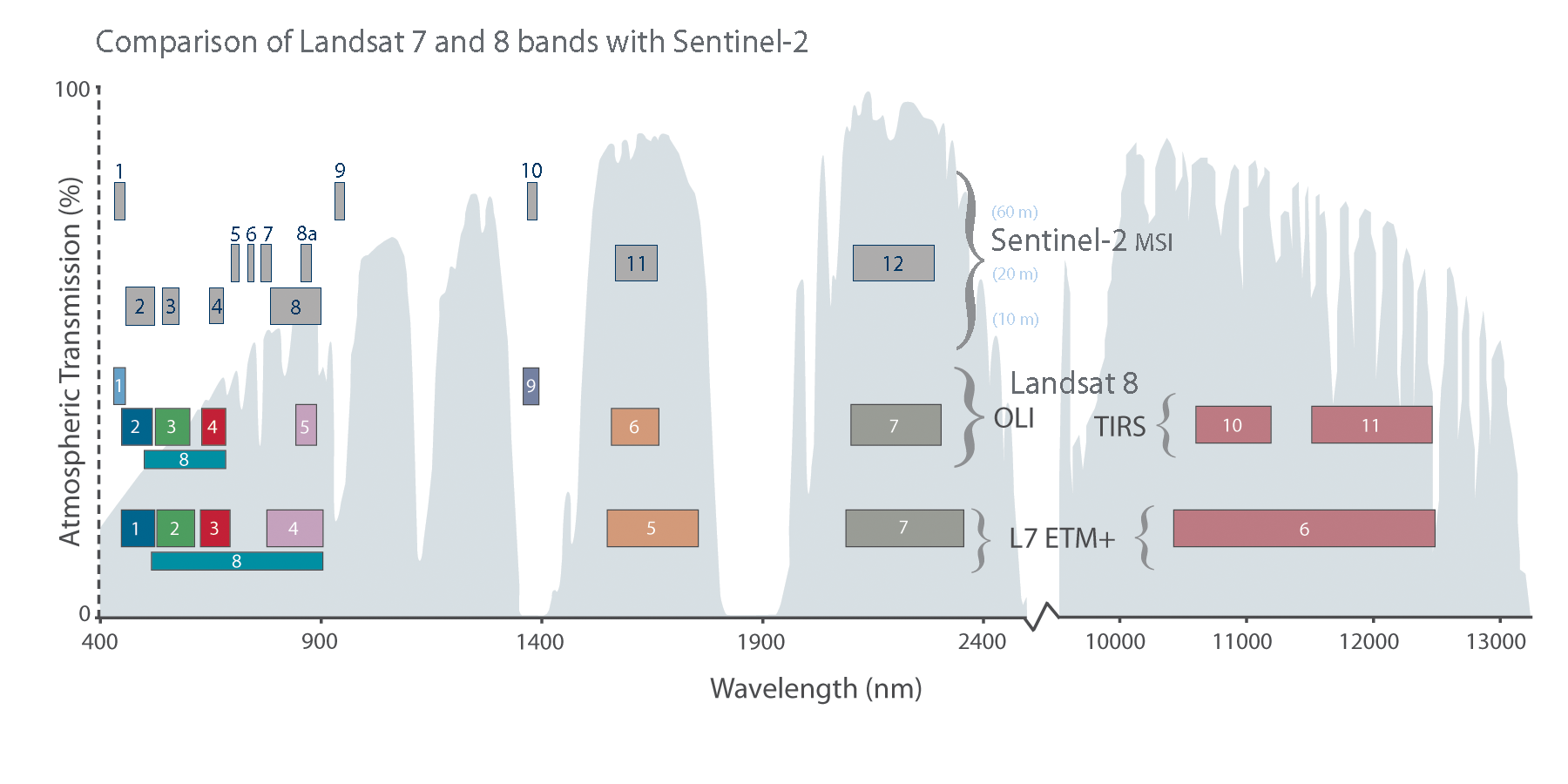
- 15m/30m/100m resolution (Landsat 8)
- average revisit time of 8-16 days
- terrain corrected -- requires radiometric calibration
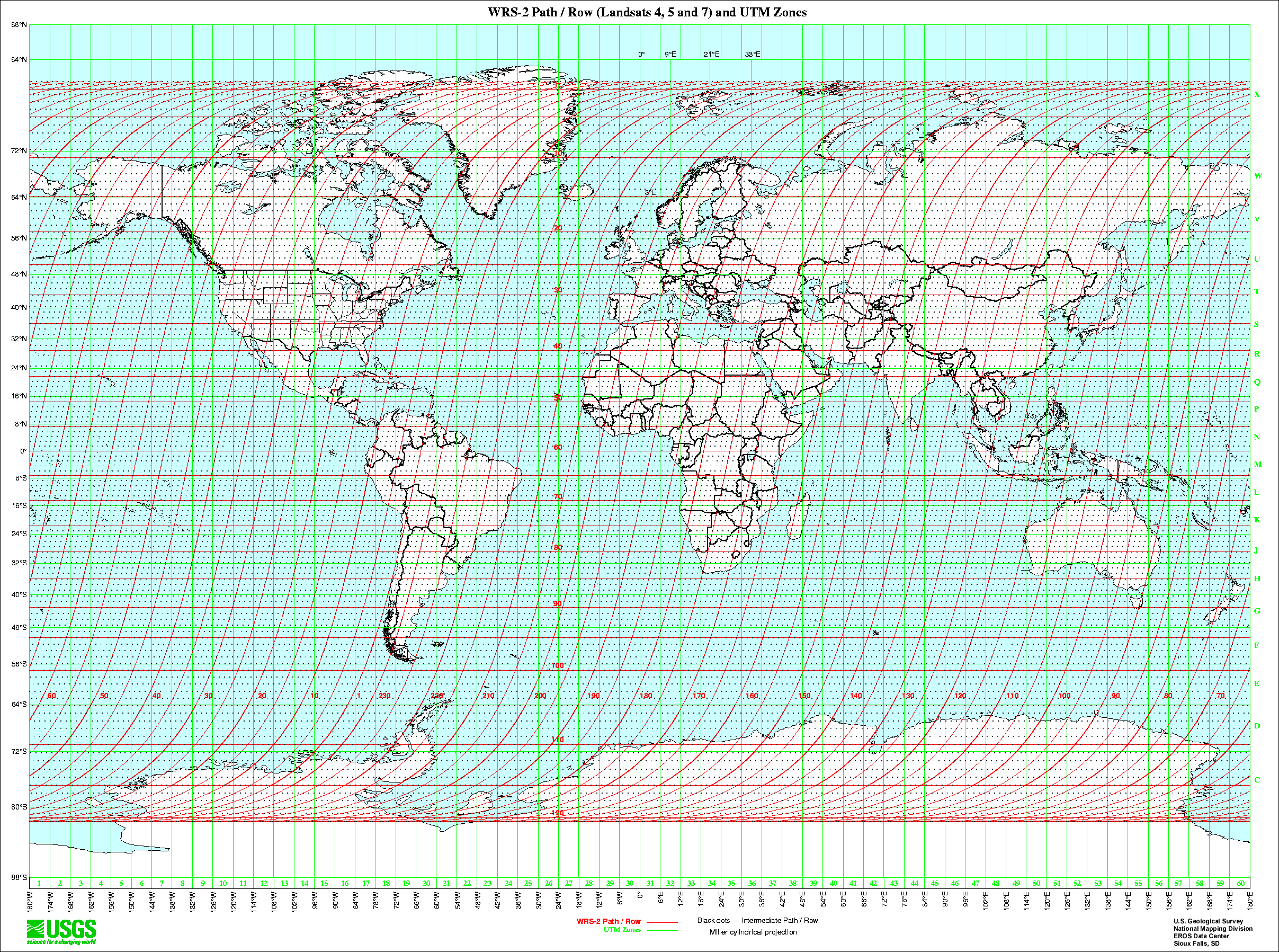
- organised in paths and rows
- level-2 data available opon request
- analysis-ready-data available for U.S.

Sentinel-2
- 10m/20m/60m resolution
- average revisit time of 5-10 days at equator
- calibrated to TOA and terrain corrected
- organised in UTM granules
- swaths and granules differ
- level-2 selectively available


USGS Earth Explorer


Alternatives for Landsat
- GloVis (USGS)
- LandsatLook Viewer (USGS)
- EO-Browser (Sinergise)
- ...
Copernicus Open Access Hub


Copernicus Open Access Hub
- Sentinel 1, 2 and 3
- cannot search by Sentinel-2 granule
Alternatives for Sentinel
- Open Hub API (ESA)
- Austrian Mirror (ZAMG)
- PEPS, French Mirror (CNES)
- Sentinel Playground (Sinergise)
- EO-Browser (Sinergise)
- Earth Explorer (USGS)
- Sentinel2Look (USGS)
- ...
QGIS Plugin
Sentinel Downloader

EO-Compass
How do you search for EO images?
...
area or location of interest
time of interest
data type
metadata (e.g. cloud cover)
...
How can you describe the contents of an archive?
...
number of images
data characteristics (e.g. resolution, frequency)
average cloud cover
...
Vision
semantic searches based on image contents
tools to better describe an archive
geovisual tools to display archive coverage and quality
better assess suitability of data source for EO analysis
...

Analysis Ready Data
&
Data Cubes
What is a data cube?
A datacube is a massive multi-dimensional array, also called “raster data” or “gridded data”; “massive” entails that we talk about sizes significantly beyond the main memory resources of the server hardware. Data values, all of the same data type, sit at grid points as defined by the d-axes of the d-dimensional datacube. Coordinates along these axes allow addressing data values unambiguously.- The Datacube Manifesto, © 2017 Peter Baumann
What is analysis ready data?
What is the Open Data Cube initiative?

Open Data Cube
- international open-source initiative
- evolved from Australian Geoscience Data Cube (AGDC)
- better leverage EO potential
- support global priority agendas (e.g. UN-SDGs)
Partner Projects


Open Data Cube Development
Operational
- Australia
- Columbia
- Switzerland
In-Development
- United States
- Taiwan
- Uganda
- Vietnam
- United Kingdom
- Georgia
- Moldova

Questions?
SE: Analysis & Modelling [Remote Sensing]
AGI-856.143 | ST 2018
Contact: hannah.augustin@stud.sbg.ac.at
GitHub: @augustinh22